The edit mode allows you to modify the allocation of blocks in a territory:
Enter edition mode
If you have just created a new territory, you will automatically enter the territory edition mode. If you want to edit an existing territory, simply click on its name in the list view of the left-hand side panel.

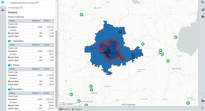
When entering edition mode, the map is centred and zoomed to the territory. The table view in the panel contains the values of the analysis criteria chosen by the user.
Select block on the map
There are several tools to select blocks in order to add or remove them from a zone or transfer them to a new zone.
Click on the selection tool in the toolbar to choose your selection tool (see here the different selection tools):

On the map, the selected blocks are displayed with a red border:

Analysis criteria table
When blocks are selected, the table view will allow you to get some information for each zone:
 The first line contains information about blocks:
- the number of blocks within the current zone (without any modification) in the column “Current”,
- the number of blocks after being added, in the column “Add”,
- the number of blocks after being removed, in the column “Remove”.
The other lines contain the aggregated values of the attributes chosen as analysis criteria…
- … for the current zone.
- … if you add blocks.
- … if you remove blocks.
Red or green arrows allow you to visualize the increase or decrease of values. Deviation with target value is also displayed for the chosen analysis criteria.
Add or remove blocks

- Click Add to add all selected blocks that are outside your territory, and chose the zone they should be added to.
- Click Remove to remove selected blocks that are within your territory
- Click Move blocks to move blocks to a different zone, and choose the destination zone.
Visualisation Options
Under the name of the territory, three visualization options allow you to adapt the map view to the information you want:
- Hide outer block: all blocks that do not belong to this territory will be hidden
- Show all territories: Primary Trade Areas of official territories will be visible on the map.
- Show calculated boundaries: the areas covered by the drive times or distances (isochrones or isodistances) used to create the territory will be displayed in gray on the map.